An 18th Century Surveying Expedition

To be held in
Charlestown, NH
Historically known as Township #4
December 16 & 17, 2006


Some background info on 18th century surveying

We are basing this weekend on the lives of such men as Matthew Patten and Samuel Lane. Both men were surveyors right here in New Hampshire in the middle of the 18th century and both left journals behind for us to study today.
 
From Lane's journal: November 25th, 1748 "I went with the Exeter people into the woods, which is the first time I ever Camp'd in the Woods."
 
He carried with him: "1 Cheese 1 Cake 6 Bisket tobacco 2 pipes Blanket compass & Stand Line protractor Dividers Book reading Book coffe Sugar 2 pair Stockins apron"
 
Lane's expedition to what is now Holderness, NH consisted of at least seven men and took thirteen days. The fall was a good time for such activity as the mosquitoes and black flies that plague the north country are no longer a problem. Surveyor Matthew Patten was actually driven out of the woods one spring by the biting bugs!
 
Lane had a surveyor's compass made by a instrument maker in Boston in 1753. It cost him 12L 10s and he paid for it in installments by having shoes sent to the instrument maker. It was not a cash based economy like we have today, and it was not unusual for a craftsman to be paid in commodities.

This is the compass we will be using for the weekend.
 
 
The other important tool used by surveyors was a Gunter's Chain. A full chain was 66' long. A half-chain like the one pictured here is 33' long, which is two rods. A rod is 16.5'. There are 100 links in a chain, each 7.92" long. Two strong men would be required to use it because it must be stretched tight. A sagging chain gives an exagerated measurement.
 
 
The chain was used to measure the distance between two points, and the surveyor would need to sight through the compass and direct the chainmen to get an accurate reading. Since it is rare that you can go in a straight line in New England without getting snagged on something, there would be axemen to assist in clearing brush along the lines.
 
At the end of the day, the notes and sketches made during the day would be made into rudimentary maps. Later, these notes and crude maps could be turned into the official boundary maps that were part of the record of the town. The lots laid out on the maps would be sold off by the proprietors who owned the land to settlers or speculators and eventually they became the towns we know today.
 

Come join us for a weekend of period surveying and mapmaking.

Participants must provide their own sleeping and eating gear.

Please pack your gear so that you can carry it all in to the camping site and back out. This is an opportunity to learn to travel light.

We will be setting up a lean-to base camp. If you have a fly or other small piece of tentage that you want to pack in, feel free to do so.

We will be eating period trail food, please plan accordingly.

Warm clothing is recomended, it is December, after all, and it can get cold at night.

Some of the area we will be surveying is overgrown with wild raspberry canes and it is a good idea to come equipped with leggings to to protect your legs and stockings.

The focus of the weekend is not shooting (for a change!), but it wouldn't hurt to have a musket or two in the party to defend against savages or wild beasts.

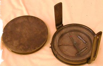
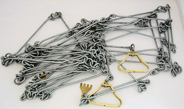
We will be providing a Gunter chain, a reasonably early styled surveyor's compass, a few axes and hatchets. It might be a good idea to bring a notepad and writing implements to take notes.

The boundary we will be surveying and marking will be approximately 1/2 mile, which encloses a 7-acre parcel of wooded land. Some terrain is reasonably flat, some rocky, and one spot may even be boggy. Dress accordingly.

For more details, contact Pete at: info@middlesexvillagetrading.com

Main Page